Liscarroll Castle, County Cork
Niall C.E.J. O’Brien
The
parish and village of Liscarroll is located about 4½ miles north-northwest from
Buttevant in County Cork. It is located in the Orrery portion of the barony of
Orrery and Kilmore. This barony was before the Norman invasion of 1169 part of
the larger kingdom of Múscraige Trí Maige (Muskerry of the three plains) which
extended westwards to include most of the barony of Duhallow. The name
Liscarroll (Carroll’s lios) possible comes from a levelled circular enclosure
(diameter c.15meters) located just north of the village and c.140meters north
of the castle.[1]
The medieval stone castle of Liscarroll is located on a limestone outcrop with
the flat floodplain of the Awbeg River to the north and upland area to the
immediate south on which the present village of Liscarroll is situated.
In
1180-83 Robert Fitzstephen Múscraige Trí Maige, then known as Muscridonegan, to
his nephew Philip de Barry, along with Killeedy in south-west Limerick and
Olethan in east Cork (now known as the barony of Barrymore). Muscridonegan was
then still in Irish hands with only Olethan available for immediate occupation.[2]
After 1200 the Barry family were overlords of Múscraige Orbraige with their
chief manorial centres at Ardnacrothen otherwise Athnacrothen (Newmarket),
Liscarroll and Buttevant.[3]
The deposed rulers of the O’Donegan family were given some land around Kanturk
and north of the town which they held into the fourteenth century.[4]
Meanwhile the bishop of Cloyne held an episcopal manor at Kilmaclennie in
Muscridonegan.[5]
In 1207 King John confirmed the previous grant of Fitz Stephen to Philip de Barry
of the three cantreds of Olethan, Muscridonegan and Killeedy to William Fitz
Philip de Barry.[6]

Liscarroll manor and parish
Liscarroll
was a demesne manor of the Barry lords but it seems didn’t possess a large fee
estate attached to it unlike its neighbouring manor of Buttevant. Instead
Liscarroll manor appears to have been confined in area to the surrounding
parish of Liscarroll.[7] In
the 1830s the parish measured 3,855 statue acres while Clonfert parish, in
western Duhallow, measured 64,871 statute acres.[8]
The Barry manor of Ardnacrothen is said to be co-terminus with the area of
Clonfert parish.[9]
In the papal taxation of circa 1300 Liscarroll parish, spelt Kylscarwyl, was
valued at 20shillings, which was nearly the lowest valuation of the twenty-two
parishes and chapels in Muscridonegan.[10] This
would suggest that Liscarroll manor was formed for military considerations and
not solely for its economic potential. The rectory of Liscarroll was impropriated
to Ballybeg priory, south of Buttevant, as were a large number of Barry
parishes.[11]
Liscarroll castle fabric description
The
stone castle of Liscarroll is a rectangular structure measuring circa 62meter
north-south and circa 50m east-west with four circular corner towers of which
three survive. The enclosing walls are circa 7m high. The stonework is rubble
limestone with a low base-batter.[12] The
presence of a base batter is common in thirteenth century castles but not in
later structures.[13] The
south wall is slightly shorter than the north wall and has a slight curve to
connect it with the south-west tower. Tadhg O’Keeffe suggested that the
builders started construction from the north end of the castle and progressed
towards the south end readjusting the ‘Vitruvian’ rectangle as they went.[14]
It would appear that the castle was built all at the same time or in phases as
the horizontal lines in the masonry are uniform.[15]

The
south wall has a centrally placed square gate tower which projects 2m out from
the curtain wall and 8m into the ward. The entrance passage is covered by a
barrel vault.[16]
The elevated passageway through the gate tower suggests a drawbridge once
crossed the surrounding moat.[17]
Inside the drawbridge are vertical recesses for a portcullis. A rebate exists
for a gate inside the portcullis while murder holes exist to greet any visitors
who could get that far in. The current blocked up wall at the north end of the gateway is a modern insert with gate to restrict visitors. The first and second floor over the entrance way are
said to be late medieval additions but some original first floor once existed.
A possible machicolation once guarded the entrance passage ad the top of the
tower would have had a wall walk but, due to the collapse of the upper floors,
certainly is not guaranteed in this regard.[18]
The
north wall has a centrally placed rectangular tower of three storeys with later
remodelling sometime after construction such as installing a fireplace and a
barrel vault roof.[19] The
garderobe chute from the top of the tower is of a late medieval date.[20] The
west wall has a ruined rectangular tower towards north-west corner of the
curtain wall. This tower had at least two floors. It may have been a later
addition to the castle to provide extract defence in that area. The three surviving
circular towers at the corners (the south-east tower is in ruins), stand three
storeys high with an entrance at the ground floor and first floor levels. The
circular towers are not uniform and vary in diameter from 3m in the south-west
tower to 3.75m in the north-west tower.[21] The
ruined south-east tower had a well within it that was used during the 1640s
war.[22] Kilbolane
castle some miles north of Liscarroll is a similar structure with two corner
circular towers and is of the same width as Liscarroll while Liscarroll is
twice the length. It is likely they both were built in the same 1260 to
mid-1270s period.[23] A
drawing of Liscarroll castle in the 1740s shows an angular bastion outside the
south gateway, crenulations on the castle wall and four sided gabled roofs on
the round towers with a moat surrounding the castle.[24]
How much this 1740s drawing reflected the current condition of the castle at
the time or was artistic licence on behalf of the artist is difficult to tell. The
gun bastions on the north side of the castle shown in the drawing can be seen
in the archaeology today. The north-west opening maybe to allow the guns to
exit and enter the castle depending on how well, or badly, the battle is going.

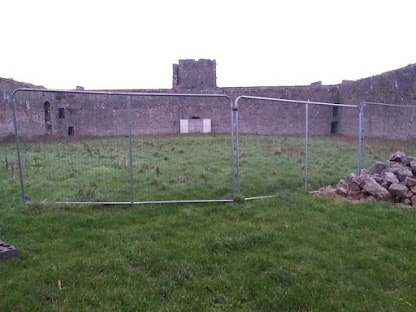
Inside Liscarroll castle
Having
viewed the outside visitors to Liscarroll are usually curious as to what lies
within the now empty ward. The curtain wall doesn’t display any signs of
buildings placed up against the wall. Liscarroll is generally referred to as a
castle but many scholars are now describing it as a towered-enclosure.[25] Geophysical
work at Ballintober castle (another empty ward castle) shows a complex of large
buildings forming a courtyard.[26]
An inquisition of Ballintober in 1333 said it was an old castle surrounded by a
stone wall.[27]
Tadhg O’Keeffe suggests that at Liscarroll there were a number of buildings
within the ward before the castle was built that were enclosed by the stone
wall for better protection. This may account for the not quite rectangular
shape of the castle as the builders line of sight was obstructed by
pre-existing buildings.[28]
The
enclosure of Liscarroll is noted to be abnormally large when compared to other
contemporary castles. The triangular area opposite the entrance gate in
Liscarroll village could have been the site of the medieval market. Maybe some
of the market was held within the castle or animals from the market or the
surrounding countryside were kept in the castle in times of war or plundering
raids. A moat site at Ballyconnor near Old Ross, Co. Wexford, was constructed
in 1282-4 to keep eight of the thirty-six oxen on the estate in a secure
location as robbers occasionally stole oxen in the area.[29] Some
test pits around the village and within the castle may provide dating evidence
for a structure that has not certain existing dating evidence. Opposite the
castle entrance and south of the suggested market place is the ruins of the
parish church of Liscarroll which was in ruins by 1615 and is located in the
townland of Coolbane.[30]
Liscarroll in the medieval records
There
is as yet no medieval document that mentions Liscarroll and the manor only gets
a brief acknowledgement that it existed without any description of its
structure. In the eighteenth century the Barrymore muniments were destroyed by
fire and with it were possibly lost documents relating to medieval Liscarroll.[31]
David Barry (1604-1642), Viscount Buttevant and heir to the Barry estates in
Muscridonegan and Olethan, became Earl of Barrymore in 1637.[32]

R.E.
Glasscock placed the construction of Liscarroll castle into the period of 1240
to 1280 along with other keepless castles such as at Castlegrace, Co. Tipperary
and Quin, Co. Clare.[33]
Castlegrace has circular corner towers with a base batter like Liscarroll. In
1263 and 1266-8 David de Barry was justiciar of Ireland.[34]
In that capacity he was aware in 1263 of people building new stone castles such
as the new castle of Moylak on the River Suir in Tipperary.[35] Liscarroll
castle may have been constructed in the 1260s in response to the crushing
defeat of the Anglo-Normans at the hands of the MacCarthy kings of south Munster
(Desmond) in 1261 at Callann in south Kerry.[36]
Liscarroll castle sits at the western end the valley of the Awbeg River which
leads to the important walled town of Buttevant. The castle faced the resurgent
Irish nations of the Duhallow barony, barring their easy access to Buttevant
and Anglo-Norman north Cork beyond. Liscarrol castle also controlled the
north-west road to the upland region around Freemount. Yet it’s impressive size
maybe for show that for solid defence. Even the arrow loops on the castle are
orientated away from the base of the curtain wall to provide proper defence.[37]
The curtain wall around the city of Oxford in England also has arrow loops that
are poorly designed for practical warfare suggesting a curtain wall for show
than for proper defence like at Liscarroll.[38]
Yet for all the slight defects the castle was able to withstand a siege of
thirteen days in 1642 against muskets an canon and so served its purpose.
In
1285-6 Sir John de Barry acknowledged before the king’s justices, that the
manors of Buttevant, Lyscarewell and Adnogrothan in Muscridonegan were held of
David de Barry and was given seisin on payment of a fine. John and David held
the manors of the chief lords of the fee which was Maurice de Careu (heir of
Robert FitzStephen) by knight’s service. At some unknown date afterwards David
de Barry alienated the manors to Robert Coffyn, chaplain, so that Robert held
the property of Maurice de Careu. This alienation continued under the reign of
Edward 1, Edward II and into the reign of Edward III so that the Barry did not
hold in chief. The Muscridonegan manors and estates were worth £60 per annum.
In 1358 the escheator seized the manors of David fitz David de Barry in Olethan
and Muscridonegan because David de Barry had alienated them to Robert Coffyn,
chaplain, to hold for David and his heirs without getting a king’s licence.
David de Barry petitioned the king for restoration and in April 1358 the king
ordered the properties in Olethan and Muscridonegan to be restored to David de Barry.[39]
Liscarroll castle in seventeenth century
By
the 1330s the MacCarthy and other Irish nations were attacking medieval
Muscridonegan.[40]
While the Barrys lost the western parts like Clonfert parish and Ardnacrothen
manor they retained Liscarroll and Buttevant to form the core of the barony of
Orrery and Kilmore. In the late sixteenth century Liscarroll castle was the
home of John of Liscarroll, fifth son of James Barry, 1st Viscount
Buttevant. John Barry (died 1627) married firstly to Joan, daughter of the
White Knight and secondly to Ellen, daughter of Dermod McTeige McCarthy.[41] In
1604 Liscarroll was still held by the Barry family with John Barry of
Liscarroll occupying the property. In that year he gave pledge, with the
MacCarthy of Kanturk, O’Callaghan of Clonmeen and O’Keeffe of Dromaghan, for
the good conduct of Laughlin McAuliffe of CastlemcAwliffe.[42]
In 1625 Sir Philip Percival acquired the manor of Liscarroll with its castle
and the property remained in the hands of his descendents until recent times.[43] Other
unidentified sources say that in 1637 King Charles made a grant of Liscarroll
to Sir Philip Percival. Meanwhile John Barry of Liscarroll was succeeded by
William Barry who was the father of John Barry of Liscarroll who married Alice,
the widow of David Barry, 1st Earl of Barrymore and daughter of
Richard Boyle, 1st Earl of Cork.[44]
on 1st April 1640 Sir Philip Percival gave the manor, town and lands
of Liscarroll, along with other property, to four trustees to hold for his
heirs.[45]

With
high ground to the south of Liscarroll castle it would seem that its use as a
military fort was made obsolete in the age of musket and canon fire but
Liscarroll was made of good construction. In October 1641, Sir William St.
Leger, Lord President of Munster, recognised the strategic importance of
Liscarrol castle at the start of the Ulster rebellion. On 4th
November 1641 Sir William St Leger wrote to John Hodder to put a ward in Liscarroll
castle, which he described as a strong medieval castle.[46] In 1642 the castle withstood a siege of
thirteen days by General Barry who had 7,000 foot soldiers and 500 horse
soldiers. In September 1642 the castle was relieved by a force of 2,000 foot
and 400 horse led by Lord Inchiquin who defeated the Irish army in a battle
near the town. In 1644 the castle again successfully kept out the Irish but in
1645 it surrendered to Lord Castlehaven without a shot.[47] In
1650 Liscarroll castle was said to be burnt and the new house built against the
outside wall had fallen into adjoining the street.[48]
After
the war Liscarroll castle was not destroyed like some other tower house castles
around the country. Instead it was repaired in later centuries with its stone
wall left intact and not used as an accessible quarry to build other houses in
the village. Nor was the interior of the castle turned into a farm yard as
happened at other medieval castles like Mogeely near Conna in east Cork.[49]
The castle awaits future archaeological investigation and its relationship to
the village and the wider landscape.
As
an after note – during the War of Independence (1919-1921) Liscarroll castle
was occupied in the winter of 1920-21 by the 17th Lancers as the
local Royal Irish Constabulary had been made ineffective. But the Lancers fared
little better as the Irish Republican Army knew the castle and its approaches.
They launched a series of attacks and broke through the walls forcing the
Lancers to evacuate back to Buttevant barracks.

==============
End
of post
==============
[1] Power, D., & Lane, S. (eds.), Archaeological Inventory of County Cork, Volume 4: North Cork, Part 2
(Dublin, 2000), no. 13608
[2] MacCotter,
P., ‘The Sub-infeudation and Descent of the Fitzstephen/Carew Moiety of Desmond
(Part 1)’, in the Journal of the Cork
Historical and Archaeological Society, Vol. 101 (1996), pp. 64-80, at pp.
64, 65
[3] MacCotter,
P., Medieval Ireland: Territorial,
political and economic divisions (Dublin, 2008), p. 157, note 69
Ardnacrothen could refer to Newmarket or to Clonfert parish.
[4] MacCotter,
P., A History of the Medieval Diocese of
Cloyne (Blackrock, 2013), p. 50
[5] MacCotter,
P., Medieval Ireland: Territorial,
political and economic divisions (Dublin, 2008), p. 157
[6] MacCotter,
P., ‘The Sub-infeudation and Descent of the Fitzstephen/Carew Moiety of Desmond
(Part 1)’, in the Journal of the Cork
Historical and Archaeological Society, Vol. 101 (1996), pp. 64-80, at p. 76
[7] MacCotter, P., ‘Medieval Buttevant: 1100-1400AD’, in Eamonn Cotter
(ed.), Buttevant: A Medieval Anglo-French
Town in Ireland (Rathcormac, 2013), pp. 29-38, at p. 37
[8] Cadogan, T. (ed.), Lewis’
Cork: A topographical dictionary of the parishes, towns and villages of Cork
City and County (Wilton, 1998), pp. 116, 331
[9] MacCotter,
P., A History of the Medieval Diocese of
Cloyne (Blackrock, 2013), p. 163. The late medieval castle of the McAuliffes
is said to occupy the site of the earlier Barry castle.
[10] Sweetman, H.S. (ed.), Calendar
of Documents relating to Ireland, Vol. 5, 1302-1307 (London, 1886, reprint
Liechtenstein, 1974), p. 277
[11] MacCotter,
P., A History of the Medieval Diocese of
Cloyne (Blackrock, 2013), p. 192
[12] Power, D., & Lane, S. (eds.), Archaeological Inventory of County Cork, Volume 4: North Cork, Part 2
(Dublin, 2000), no. 14335
[13] O’Keeffe, T., Medieval Irish
Buildings, 1100-1600 (Dublin, 2015), Plate VIII
[14] O’Keeffe, T., ‘Liscarroll Castle: a note on its context, function,
and date’, in Eamonn Cotter (ed.), Buttevant:
A Medieval Anglo-French Town in Ireland (Rathcormac, 2013), pp. 51-66, at
p. 63
[15] O’Keeffe, T., Medieval Irish
Buildings, 1100-1600 (Dublin, 2015), p. 238
[16] Power, D., & Lane, S. (eds.), Archaeological Inventory of County Cork, Volume 4: North Cork, Part 2
(Dublin, 2000), no. 14335
[17] Author’s
observations
[18] Power, D., & Lane, S. (eds.), Archaeological Inventory of County Cork, Volume 4: North Cork, Part 2
(Dublin, 2000), no. 14335
[19] Power, D., & Lane, S. (eds.), Archaeological Inventory of County Cork, Volume 4: North Cork, Part 2
(Dublin, 2000), no. 14335
[20] O’Keeffe, T., Medieval Irish
Buildings, 1100-1600 (Dublin, 2015), p. 290
[21] Power, D., & Lane, S. (eds.), Archaeological Inventory of County Cork, Volume 4: North Cork, Part 2
(Dublin, 2000), no. 14335
[22] Lomas, S.C. (ed.), Report on the manuscripts of the
Earl of Egmont, Vol. 1, Part 1 (London, 1905), p. 155
[23] O’Keeffe, T., Medieval Irish
Buildings, 1100-1600 (Dublin, 2015), p. 246
[24] O’Keeffe, T., ‘Lohort Castle: Medieval Architecture, Medievalist
Imagination’, in Journal of the Cork Historical and Archaeological Society,
Vol. 118 (2013), pp. 60-70, at p. 65
[25] O’Keeffe, T., ‘Liscarroll Castle: a note on its context, function,
and date’, in Eamonn Cotter (ed.), Buttevant:
A Medieval Anglo-French Town in Ireland (Rathcormac, 2013), pp. 51-66, at
p. 63
[26] O’Keeffe, T., ‘Liscarroll Castle: a note on its context, function,
and date’, in Eamonn Cotter (ed.), Buttevant:
A Medieval Anglo-French Town in Ireland (Rathcormac, 2013), pp. 51-66, at
p. 59
[27] Knox, H.T.,
‘Occupation of Connacht by the Anglo-Normans after A.D. 1237, continued’, in
the Journal of the Royal Society of
Antiquaries of Ireland, Vol. 33 (1903), pp. 58-74, at p. 59
[28] O’Keeffe, T., ‘Liscarroll Castle: a note on its context, function,
and date’, in Eamonn Cotter (ed.), Buttevant:
A Medieval Anglo-French Town in Ireland (Rathcormac, 2013), pp. 51-66, at
p. 59
[29] Barry, T.B., The Medieval
Moated Sites of South-Eastern Ireland: Counties Carlow, Kilkenny, Tipperary and
Wexford (British Archaeological Report, No. 35, 1977), p. 96
[30] Power, D., & Lane, S. (eds.), Archaeological Inventory of County Cork, Volume 4: North Cork, Part 2
(Dublin, 2000), no. 14413
[31] MacCotter, P., ‘Medieval Buttevant: 1100-1400AD’, in Eamonn Cotter
(ed.), Buttevant: A Medieval Anglo-French
Town in Ireland (Rathcormac, 2013), pp. 29-38, at p. 36
[32] O’Brien, J., ‘Denny Muschamp and The Ploughlands of Grange’, in
Eamonn Cotter (ed.), Buttevant: A
Medieval Anglo-French Town in Ireland (Rathcormac, 2013), pp. 103-112, at
p. 105
[33] Glasscock, R.E., ‘Land and people, c.1300’, in Art Cosgrove (ed.), A new history of Ireland, Vol. II: Medieval
Ireland, 1169-1534 (Oxford, 2008), pp. 205-239, at p. 219
[34] O’Keeffe, T., ‘Liscarroll Castle: a note on its context, function,
and date’, in Eamonn Cotter (ed.), Buttevant:
A Medieval Anglo-French Town in Ireland (Rathcormac, 2013), pp. 51-66, at
p. 63; Sweetman, H.S. (ed.), Calendar
of Documents relating to Ireland, Vol. 2, 1252-1284 (London, 1877, reprint
Liechtenstein, 1974), p. 205
[35] Sweetman, H.S. (ed.), Calendar
of Documents relating to Ireland, Vol. 2, 1252-1284 (London, 1877, reprint
Liechtenstein, 1974), p. 205
[36] O’Keeffe, T., ‘Liscarroll Castle: a note on its context, function,
and date’, in Eamonn Cotter (ed.), Buttevant:
A Medieval Anglo-French Town in Ireland (Rathcormac, 2013), pp. 51-66, at
p. 63
[37] O’Keeffe, T., ‘Liscarroll Castle: a note on its context, function,
and date’, in Eamonn Cotter (ed.), Buttevant:
A Medieval Anglo-French Town in Ireland (Rathcormac, 2013), pp. 51-66, at
p. 55
[38] YouTube,
University of Oxford, The Architecture of New College, Oxford: Julian Munby
[39] https://chancery.tcd.ie/document/close/32-edward-iii/25
(accessed 29th August 2021)
[40] MacCotter, P., ‘Medieval Buttevant: 1100-1400AD’, in Eamonn Cotter
(ed.), Buttevant: A Medieval Anglo-French
Town in Ireland (Rathcormac, 2013), pp. 29-38, at p. 36
[41] Burke’s Irish Family Records, 1976, p. 73
[42] Curtis-Clayton, M. (ed.), The Council Book for the Province of
Munster, c.1599-1649 (Dublin, 2008), p. 129
[43] Power, D., & Lane, S. (eds.), Archaeological Inventory of County Cork, Volume 4: North Cork, Part 2
(Dublin, 2000), p. 521
[44] Burke’s Irish Family Records, 1976, p. 73
[45] Lomas, S.C. (ed.), Report on the manuscripts of the
Earl of Egmont, Vol. 1, Part 1 (London, 1905), p. 114
[46] Lomas, S.C. (ed.), Report on the manuscripts of the
Earl of Egmont, Vol. 1, Part 1 (London, 1905), p. 143
[47] Cadogan, T. (ed.), Lewis’
Cork: A topographical dictionary of the parishes, towns and villages of Cork
City and County (Wilton, 1998), pp. 330, 331
[48] Lomas, S.C. (ed.), Report on the manuscripts of the
Earl of Egmont, Vol. 1, Part 1 (London, 1905), p. 500
[49] Power, D. (ed.), Archaeological
Inventory of County Cork, Volume 2: East and South Cork (Dublin, 1994), no.
5556
Dear Mr. O'Brien,
ReplyDeleteI'm writing on behalf of Dr. Givens who is publishing a book and interested in using your image of Okyle church to accompany his commentary. We'd be happy to reimburse you financially for copyright permission. Please email me at madilyn.abbe@gmail.com